Watershed Assessment and Preservation: A Unique Geo-Decision Tool for New Caledonia's North Province.
Background
Until recently, the maintenance of watercourses was deemed inefficient relative to the budgets allocated. Faced with current public finance constraints, the North Province needed to rethink its approach. It became necessary to work at the overall watershed scale and prioritize interventions where the stakes (human, material, environmental) are most critical.
The objective entrusted to the MAGIS and JBS Environnement consortium was clear: to propose a tool that could both establish a health diagnosis of the watersheds and prioritize intervention areas.
Solution: Intelligent Multi-Criteria Modeling
To meet this challenge, we developed an extremely sophisticated spatial processing model capable of digesting and analyzing a massive amount of heterogeneous data.
The core of our solution relies on ArcGIS Pro and Model Builder technologies. We cross-referenced dozens of indicators grouped into major categories:
-
Stakes: Assets (infrastructure, bridges, buildings), the environment (mangroves, protected areas), people (populations in flood-prone or isolated areas), and uses (drinking water catchments).
-
Condition and Impacting Factors: Areas degraded by mining, recurrence of bushfires, erosion, and industrial facilities (ICPE).
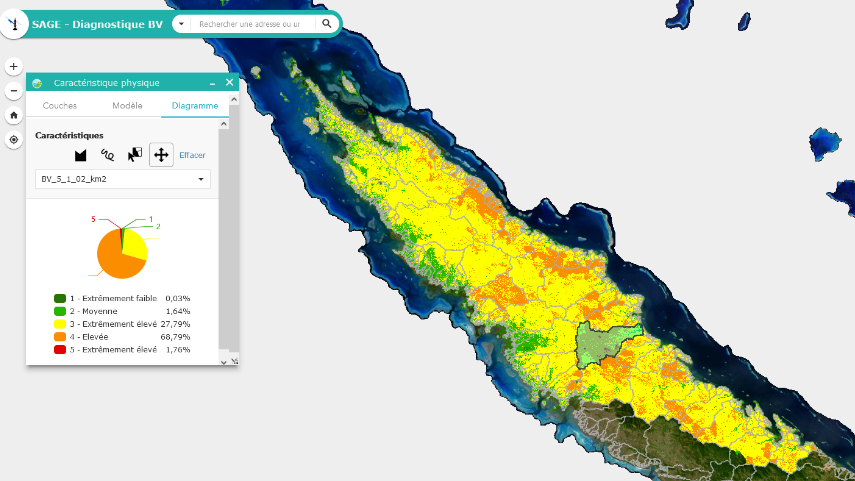
Using the Suitability Modeler, we were able to reclassify this data on a common scale and weight it to create a true suitability map. These results were then published via ArcGIS Image Server.
The real strength of this project lies in its delivery. We deployed a Web AppBuilder application incorporating a custom widget.
This interactive tool now allows decision-makers in the North Province to:
-
Create real-time scenarios: The user can adjust the weight (in percentage) of each indicator themselves, according to their current strategic priorities.
-
Visualize results instantly: The application generates a chart showing the distribution of risk classes in the studied area.
-
Target field action: A final processing step assigns a priority score to each section of the hydrographic network, precisely guiding technical teams on the ground.